EDP Labelec relies on very special help to control the quality of its grid and electrical assets. Welcome to the drone age.
An electricity company must be able to continuously carry this commodity to its destination - whether it is industries, electric vehicles, or simply our home appliances. This is the purpose of electricity grids: networks consisting of high-, medium- and low-voltage cables that carry electricity produced in generating centers - such as wind farms and hydro or thermal plants - all across the nation.
But a cable network of this magnitude requires close surveillance and maintenance to ensure perfect operating conditions. And this is a big challenge - as big as the thousand-kilometer-long power grid that spans the country. How to ensure an effective and timely inspection of the various grid sections spread across the country?
First on foot... then by air
From the 1980s onwards, the solution was "foot patrolling" by professionals who would inspect electricity cables in search of anomalies. But over time, as technology evolved, inspections evolved as well.
Helicopters were the initial solution, but these were gradually replaced by smaller and more sophisticated flying devices - the famous 'drones'.
EDP Labelec made the first attempts to bring power line inspections to another level of engineering and innovation. Focusing on the creation of innovative energy solutions, EDP Labelec is EDP's Center for Technical Excellence.
Comprising over 100 professionals, the company develops energy projects focusing on such areas as the Environment, Certification and Qualification, Energy Consulting, and Tests and Trials. It is under the latter that power line inspections are carried out.
Potential grid problems
In 1994, Labelec began using manned aerial vehicles (helicopters) to inspect power lines, with the dual purpose of carrying out thermo graphic and visual assessments.
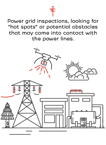
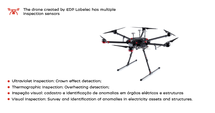
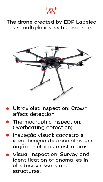
Thermography required the presence of a specific camera that would allow the company to assess the temperature of power lines and conductors. Overheating would be a symptom of a potential problem in the power grid. Thus, the helicopter carried a thermographic camera operator who recorded temperatures and detected the anomalies resulting from the so-called "hot spots."
The visual assessment was carried out by another colleague on the helicopter, who focused on visible defects - anything the human eye could detect.
In 2006 the inspection process became triple-faceted, as a sensor called LiDAR was added to visual and thermographic control. This is a laser system that makes it possible to measure the distance between power lines and identify potential obstacles that may cause problems to the grid.
Building a drone
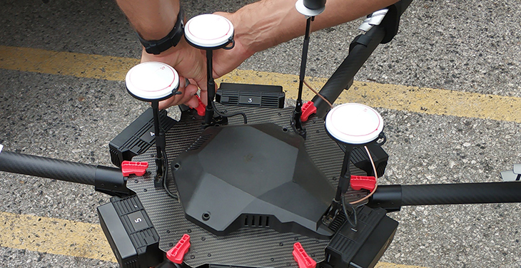
The idea of using drones as an alternative to helicopters emerged in 2015, and Labelec itself took on the mission of studying and developing this solution.
The project's first challenge was to build the drones themselves, as the solutions available in the market were not adequate for this kind of activity. This led to a partnership with the Systems and Computer Engineering Institute (INESC-TEC, based in Porto), which resulted in two drone models that are still operating today.
The drone design was specified by Labelec, according to instructions provided by INESC-TEC, which was assigned the task of creating a control system for the device. The only elements purchased by the company were the engines, as they were available on the market. The remaining hardware was built by Labelec.
However, building drones requires a level of investment which was no longer justified once the market began to offer sturdier solutions.
Therefore, the company is no longer focused on building the devices, which can simply be purchased. The main concern now is to find ways to process the huge amount of data collected, so as to deliver it to customers requesting this service, in a simplified and easy-to-apply manner.

Tireless inspectors
Labelec provides services to several clients; that is, drones operate on a daily basis to respond to requests that justify this operation, always with the aim of delivering results to a particular customer - be it internal (EDP itself) or external.
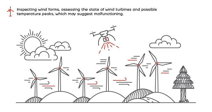
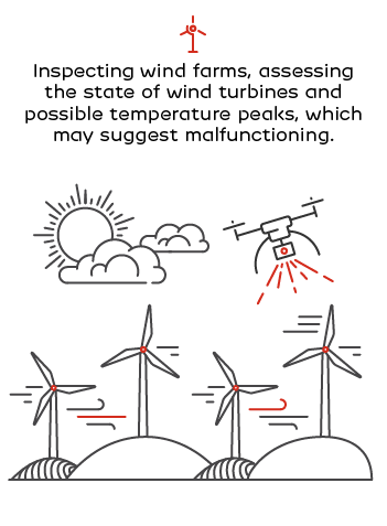
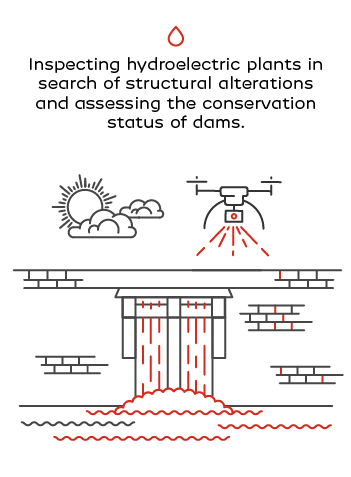
Drones are used for inspecting various electricity sector assets, from power lines to production centers themselves: dams, wind and solar farms, power plants, and so on. But drones can be used for all kinds of aerial monitoring activities.
The device flies over electricity assets looking for any defects and collects a large amount of data, including the concrete location of all situations requiring intervention.


For instance, thermographic inspections play a crucial role in the operation of photovoltaic panels in solar farms, making the drone an excellent tool. When a photovoltaic cell interrupts the production of electricity, it presents an abnormally high temperature due to the overheating that occurs before the system fails. Thermography cameras installed in drones capture a “thermal map” of the site, making it possible to identify damaged photovoltaic cells. Such data result in a complete report, available on an interactive platform, through which the necessary repairs can be planned.
Another advantage of using drones is their resistance to the most difficult weather conditions, especially when monitoring onshore or offshore wind turbines. Sensors in the on board navigation system make it possible to control the position of the drone vis-a-vis any obstacles, which in turn makes it possible to inspect assets in a fully independent manner, without resorting to a specialized operator, and to repeat the process whenever necessary. Drones make it possible to inspect various assets at heights, distances and angles which would otherwise not be possible.
According to Labelec's Director of Tests and Trials Rui Martins, the introduction of drones has been a success: "It was a surprise, market acceptance is very interesting. So we believe that in a year or two, we will double our drone fleet. We believe it is a safe, reliable tool that can be adjusted to the various kinds of work required by our customers, so we think it has come to stay."
Planning to fly higher
Drone types and data analysis possibilities are expected to evolve in the future. Currently, Labelec operates rotary wing drones only, but there are also fixed wing drones - a device the company is also planning to use.
"At this moment we only operate rotary wing drones, which ensure good proximity to assets and inspection details that helicopters can't offer," says Rui Martins. “So, for us, drones complement helicopter inspections.” While a helicopter flies at 30 km/h and can cover about 20,000 km per year, drones are used for more localized jobs that do not require long distances.

"It has been very challenging and you can see that people are motivated. For now this is a new technology, which shows that EDP and Labelec are interested in new challenges. And we have had a lot of support from the Labelec BoD and the EDP Group, so we can implement a solid and value-added project for Labelec and its customers." Rui Martins, Tests and Trials Director, EDP Labelec
Besides intending to expand drone types, Rui Martins also would also like to increase their automatism. Current flights are planned in advance: the operator enters the coordinates of the sites to be analyzed and gives the flight order. From there, the drone becomes autonomous and carries out the inspection. But this is not enough. "How to process so many data terabytes automatically? At the end of the day, what our customers want is to receive added value information about the inspected assets. And that's the big challenge," he says.

